MOUNTAINS: MERCURIAL, MYSTIC, MAJESTIC, MAGNIFICENT


My Dad in the 1930s with,
I think, Mt. Shasta behind him. Or it
could have been Mt. Lassen? Both are in
California's Cascade mountain range.
Unfortunately there was no description on the back of the photograph.

Mount. Shasta. I tobogganed somewhere up there in the early '60s back when Shasta boasted a ski resort. The town at the foot of the mountain is Mount Shasta City.

Mt. Shasta seen from the
small community of McCloud, with a red barn to add an artistic touch.

Lake Almanor in northern Calif. where the Sierra and Cascade mountain ranges meet, with Mount Lassen in the background.

Mt. Edgecumbe in Sitka, Alaska. We were here in 1997 to visit friends. It’s an amazing place with hundreds of large and small forested islands all around – some of the larger ones supporting homes which have to supply their own water, sewer systems, & electricity. And of course they have to take a boat to town to buy groceries, see a doctor, or whatever. And stunning Mt. Edgecumbe looms over all. All three of the mountains shown so far are dormant volcanos.

Twenty years later we took a guided tour of Alaska and saw mystic Denali (Mt. McKinley) in its full glory. “Denali” in the Koyukon Athabaskan culture means “The High One” or “The Great One”. President Barack Obama and Secretary of the Interior, Sally Jewell, officially changed the mountain’s name from Mount McKinley to Denali in 2015, but it was changed back by President Donald Trump earlier this year. L
We were told only 30% of visitors are able to see it this way, so I guess we were lucky. Denali is not officially listed as a volcano, but because of its proximity to the Pacific Rim of Fire which includes countless volcanos in California, Oregon, Washington, British Columbia, the Yucon, and Alaska, some theorize it may have once upon a time, been one.

The mountains of Six
Rivers National Forest. In 1972 we drove
up that logging road to watch some helicopter logging going on . . .

. . . and made a picnic out of it with sandwiches, chips, and drinks while we watched the logging. Interesting, and very loud!

The helicopter hovers as chains are lowered to the loggers on the ground who hook them around the log or logs to be lifted, then dive out of the way as the helicopter lifts and carries them over to the deck where loggers there unhook them and load them onto a truck. It takes precision, but it all went smoothly while we were watching. That's one heckuva big helicopter, by the way - a Sikorsky Skycrane.

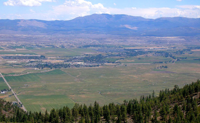
Okay, so now we're on our way to Lake Tahoe. One way to get there from where we live is over Echo Summit on CA state
highway 50 which, at the summit, offers a momentary look at the lake before the highway descends. I believe that's the Tahoe airport off to the right. We rarely drive to Tahoe this way, but the
summit does provide a gorgeous view.

The view from Carson Spur
at 7990 ft. elevation on CA state hwy 88.
It’s another 5+ miles to Carson Pass at 8,574 ft.
We have friends living in Gardnerville, Nevada in the Carson Valley so we usually drive to Lake Tahoe over either Sonora Pass on CA state highway 108, or I like to go over Carson Pass on hwy 88. Either way is a pretty drive, but I think 88 has more spectacular views – such as this one from the Carson Spur lookout, plus it skirts four pretty lakes along the way and besides that, has more passing lanes! We drive straight on over to Gardnerville to visit with our friends for a while, then drive up the east side of the mountains to Tahoe.

The east side of the
Sierras as seen from Carson Valley.
Approaching the passes over the Sierras from the west the mountains rise gradually, but on the east side they stick straight up from the valley floor. Of course the valley floor is already at 5000 feet so to cross the summit of Kingsbury Grade which we do heading to Tahoe from our friends’ place, we only have to climb another steady 3000 feet. And the highway is good with multiple turnouts for slower traffic (if they'll use them?)

Kingsbury Grade headed for Tahoe – leaving Carson Valley behind.
A sweeping view of Carson
Valley from further up the grade.

After crossing Dagget Summit
on Kingsbury Grade the route winds down the west side of the mountains to this
first view of the lake which sits at 6200 feet elevation. To get to our destination of Meeks Bay we drive
around the south end of the lake and head north up the west side on CA state route
89 passing famous Emerald Bay along the way.

Emerald Bay with Fannette Island and its stone tea house on top. I climbed up there a 'few' years ago. The view from up there is quite something.

A peek through the trees
at the resort approaching Meeks Bay on hwy 89 from the south.

This splendid view of Rubicon
Peaks is seen just before reaching Meeks Bay coming from the north end of the lake on hwy 89. We usually rent a cabin in Tahoma a mile north
of Meeks so we see this pretty view every day on our way to the beach when we’re
vacationing there.

Sometimes we choose to
take a different way home and Monitor Pass is another route over the mountains
connecting with CA state highway 4 and Ebbets Pass. It’s another pretty route but steep and curvy
in spots and near the top of Ebbets Pass the road actually becomes too narrow to
host a center line. RVs are not
encouraged to take this route, but some idiots do anyway.

There’s room for two cars
to carefully pass, but RVs make it difficult.
At least there are white lines
to mark the edges of the road.

Now we’re on our way to Yosemite National Park and amazing Yosemite Valley, so we head up Priest Grade on CA state highway 120 (or Old Priest Grade - a shorter, steeper route, but no big switchback curves), passing through a couple of small communities on the way like this one where I lived for 28 years.

The Tuolumne River Canyon
with the Sierras in the background near “Rim of the World” lookout off hwy 120
on the way to Yosemite.

The spectacular Tunnel
View* entrance to Yosemite Valley.
Bridalveil Fall on the right nestled beneath Cathedral Rocks. Center in the distance is the tip of Half
Dome. And on the left, the massive El
Capitan.

Eldest daughter posing at Tunnel View* in 1993.

Younger daughter at the same spot in 1996.
:->
La Nightingail
*Tunnel View is named for the view one sees on exiting Wawonna Tunnel on CA state hwy 41 - approaching the Valley from the south.

Entering Wawonna Tunnel from
the south on CA state hwy 41 on the way to Yosemite Valley.

Driving through the
tunnel.

The sudden dramatic view of Yosemite Valley on exiting the tunnel. J


What an amazing collection of mountain views and roads going up, around, over and offering overlooks! I'm still calling it Denali, just as the Gulf of Mexico remains that name.
ReplyDeleteYes! It will always be "Denali" That's what it first was and should always have been!
ReplyDeleteBeautiful photos! I love the awesome drama of mountains and just this morning discovered some spectacular pictures of mountains in Iran that I had never heard of. Look up "Mount Damavand". Your photo of Ebbets Pass at 8,730 ft is 3,000 higher than Mount Pisgah here in western NC which I look at every day. Sometimes white clouds further west will create an illusion of a massive range beyond the Great Smokies, looking like the Alps or the Himalayas. The world is filled with wonders, real and imagined.
ReplyDelete